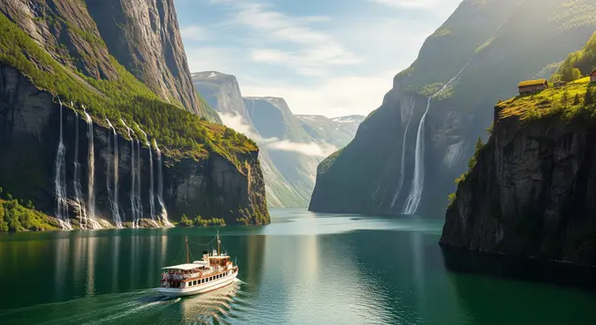
Norway is home to some of the most striking landscapes on Earth, shaped by centuries of glacial activity. This quiz looks at the unique features and history of the famous Norwegian fjords.
You will see questions about specific locations like Geirangerfjord and Nærøyfjord, along with details regarding their formation and local folklore. Some questions are straightforward, while others ask you to remember small details about the region.
When you finish, try natural wonders, mountain landscapes, or UNESCO architecture to keep going.
Which natural phenomenon was primarily responsible for the formation of Norwegian fjords?
Glacial erosion
Glacial erosion
Tectonic plate collision
Tectonic plate collision
Volcanic activity
Volcanic activity
River erosion
River erosion
What geological shape is characteristic of a fjord?
Circular basin
Circular basin
V-shaped valley
V-shaped valley
Flat-bottomed canyon
Flat-bottomed canyon
U-shaped valley
U-shaped valley
Which international designation is shared by the Geirangerfjord and Nærøyfjord?
European Geological Reserve
European Geological Reserve
UNESCO World Heritage Site
UNESCO World Heritage Site
National Marine Park
National Marine Park
International Biosphere Reserve
International Biosphere Reserve
Which fjord is famous for the ‘Seven Sisters’ waterfall?
Hardangerfjord
Hardangerfjord
Sognefjord
Sognefjord
Geirangerfjord
Geirangerfjord
Sunndalsfjord
Sunndalsfjord
How many individual streams make up the ‘Seven Sisters’ waterfall?
Seven
Seven
Nine
Nine
Eleven
Eleven
Five
Five
What is a defining visual feature of the Nærøyfjord?
Sandy beaches and coral reefs
Sandy beaches and coral reefs
Steep cliffs that rise directly from the sea
Steep cliffs that rise directly from the sea
Flat, low-lying coastal plains
Flat, low-lying coastal plains
Mangrove forests along the edges
Mangrove forests along the edges
What is the most common way for tourists to experience the Norwegian fjords?
By ferry cruises
By ferry cruises
By underground tunnels
By underground tunnels
By high-speed trains
By high-speed trains
By bicycle paths
By bicycle paths
In which year were the Geirangerfjord and Nærøyfjord inscribed on the UNESCO World Heritage list?
2005
2005
1995
1995
2000
2000
2010
2010
According to local folklore, which waterfall is said to be ‘courting’ the Seven Sisters?
Vøringsfossen waterfall
Vøringsfossen waterfall
Suitor waterfall
Suitor waterfall
Bridal Veil waterfall
Bridal Veil waterfall
Tvindefossen waterfall
Tvindefossen waterfall
The name ‘Nærøyfjord’ is derived from the Old Norse term for what feature?
Depth of the water
Depth of the water
Narrowness
Narrowness
Length of the shoreline
Length of the shoreline
Number of glaciers
Number of glaciers
What geological process describes the slow rising of the land after the heavy ice sheets melted from the fjords?
Isostatic depression
Isostatic depression
Glacial rebound
Glacial rebound
Continental drift
Continental drift
Seafloor spreading
Seafloor spreading
Which village is located at the inner end of the Nærøyfjord?
Flåm
Flåm
Gudvangen
Gudvangen
Aurland
Aurland
Geiranger
Geiranger
Which sea is primarily associated with the main body of the Norwegian fjords?
Barents Sea
Barents Sea
Baltic Sea
Baltic Sea
Norwegian Sea
Norwegian Sea
North Sea
North Sea
What form of propulsion is increasingly being mandated for cruises in the Geirangerfjord to protect the environment?
Coal-fired engines
Coal-fired engines
Steam-powered engines
Steam-powered engines
Diesel propulsion
Diesel propulsion
Electric propulsion
Electric propulsion
Why do large cruise ships have access into many Norwegian fjords despite their massive size?
The fjord reaches depths of up to 50 meters
The fjord reaches depths of up to 50 meters
The fjord reaches depths of up to 500 meters
The fjord reaches depths of up to 500 meters
The fjord reaches depths of up to 200 meters
The fjord reaches depths of up to 200 meters
The fjord reaches depths of up to 100 meters
The fjord reaches depths of up to 100 meters
What is the width of the narrowest part of Nærøyfjord?
250 meters
250 meters
1,500 meters
1,500 meters
2,500 meters
2,500 meters
500 meters
500 meters
The Geirangerfjord is surrounded by which dramatic mountain range?
The Hardangervidda Plateau
The Hardangervidda Plateau
The Dovrefjell Range
The Dovrefjell Range
The Sunnmøre Alps
The Sunnmøre Alps
The Jotunheimen Mountains
The Jotunheimen Mountains
Which historical mountain farm, accessible by trail or boat, overlooks the Geirangerfjord?
The Troll’s Path
The Troll’s Path
The Skageflå farm
The Skageflå farm
The Preacher’s Pulpit
The Preacher’s Pulpit
The Eagle’s Bend
The Eagle’s Bend
What feature primarily determines if a coastal inlet is technically a fjord?
The tidal range of the fjord floor
The tidal range of the fjord floor
The height of the surrounding mountains
The height of the surrounding mountains
The salinity of the water at the surface
The salinity of the water at the surface
Glacial erosion creating a U-shaped valley
Glacial erosion creating a U-shaped valley
The Nærøyfjord is a branch of which major Norwegian fjord?
Hardangerfjord
Hardangerfjord
Sognefjord
Sognefjord
Aurlandsfjord
Aurlandsfjord
Lysefjord
Lysefjord
Which famous road is known for its eleven hairpin bends and steep incline as it ascends from the Geirangerfjord?
The Flåm Railway
The Flåm Railway
The Atlantic Ocean Road
The Atlantic Ocean Road
The Troll Road (Trollstigen)
The Troll Road (Trollstigen)
The Eagle Road
The Eagle Road
Why can the surface water of a fjord often have lower salinity than the deep water?
The influx of freshwater from mountain snowmelt and rivers
The influx of freshwater from mountain snowmelt and rivers
The high salt concentration caused by evaporation
The high salt concentration caused by evaporation
The high volcanic heat from geothermal vents
The high volcanic heat from geothermal vents
The lack of connection to the open sea
The lack of connection to the open sea
You can do better
Not bad
Great!
If you enjoyed these questions, you might also like our quizzes on travel curiosities, engineering feats, or historic sites.